Ten Mile Haul Road -- South | ||
click for North section click for larger map click for the legend click for North section  click for larger map |
Ten Mile Haul Road | ||
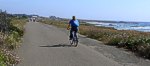
The southern end of this decaying thread of asphalt runs across the western margin of the coastal plain, nearly always in sight of the booming Pacific. This is Fort Bragg's ocean promenade (the best land having been appropriated by the now defunct lumber mill. Like Big River's haul road to the south, during daylight hours in all but the worst weather, you'll see others promenading, jogging, walking (leashed) dogs, bicycling, and otherwise enjoying the ocean exposure.
The Haul Road is most easily accessible from a parking lot just past the first motel north of Pudding Creek, Fort Bragg's northern boundary. There's a porta-potty here, and then a long stretch of road and a broad stretch of ocean. The trail runs on the ocean side of several more motels, then a cement plant, before heading off across the windswept coastal plain.
Three-quarters of a mile along, the haul road dips down to a bridge over Virgin Creek. This beach is a favorite of local surfers and of the ground nesting Snowy Plover. For the preservation of these wonderful birds, it is critically important that dogs be leashed and kept in tight control here. Signs on the right side of the road reveal a sharp difference of opinion among conservationists on the proprieties of feeding the wildlife.
The plywood lighthouse is the unofficial one-mile marker, although the real milepost is a few paces along. In some kinds of weather, the promenade into the gale's teeth thankfully turns back here.
Not far past Virgin Creek the road starts across the coastal plain, and the houses thin out and back off. Wind-sculpted bush communities punctuate hardy headlands grasses. The equestrian trail comes up off the beach and parallels the road, offering a more grounded but uneven path. Paths scallop out along headlands, branch down to pocket beaches to the west and access points to the east. One sandy headland is home to a busy bumblebee colony. Places to sit and admire Nature abound.
1.6 miles along, the haul road turns inland into a Shore Pine forest, and the other trails tend to head out toward Laguna Point and its boardwalk, story signs, and Sea Lion rookery. The boardwalks head back to the parking area in McKerricher State Park, a toilet ...and another trailhead. Not far on past the parking lot -- seek the path northwest of the trees to avoid the vehicles.
Just past the 2-mile mark, the Haul Road passes over the Park road on a trestle. A short scramble or a leisurely detour connects the Haul Road with the Laguna Point footpaths. The Road continues on north, passing Ward Avenue, then petering out, only to re-emerge a mile later for the spectacular Ten Mile Haul Road - North.
Also at McKerricher, a trail leads around Lake Cleone. This trail has been closed for some time due to boardwalk failure. The new boardwalks on Laguna Point are made of recycled plastic bottles in the form of TrexTM which appears to weather better here in the abrasive marine environment.
|
This page is sponsored by the Caspar Community "Improving the quality of all life in Caspar" |
 | ||
| site designed and posted by the Caspar Institute this site generated with 100% recycled electrons! send website feedback to the MendoWalks webster | |||